This tutorial taught you how to georeference a scanned document. Here’s a few notes to discuss the issues and key points surrounding this process.
1. QUALITY OF THE SCANNED DOCUMENT
It is essential that your document has a very high resolution. GIS functions at a pixel-level precision, since lat/long coordinates tend to be very specific. A 800×600 image could by no means ensure that your control points (see step 3) are precise enough. If you scan your image yourself, make sure that you select the highest resolution available. Map websites such as the David Rumsey Collection offer resolutions of over 12,000 pixels.
Make sure that your scanned image has been vertically taken or scanned. If you took a picture yourself whilst in the archives, the fact that the picture wasn’t taken at a 90° angle will make it almost impossible for the georeferencing tool to work out what coordinates the control points really correspond to.
2. ACCURACY OF THE SCANNED DOCUMENT

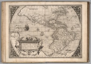
(Credits: David Rumsey Collections)
Mapping is a wonderful process; what cartographers achieved without our technological comfort is incredible, but do remember that most maps before the Enlightenment are just not precise enough to expect to be perfectly georeferenced. Georeferencing is primarily a tool for 19th, 20th and 21st Century historians.
However, this does not mean that you can’t use a more modern map to depict a process happening in older times!
3. CONTROL POINTS
For QGIS to fully georeference your scanned image, you will need to give at least 3 or 4 control points. These are points on the map for which the exact coordinates are known. In the case of a map of London, Big Ben, the front gate of Buckhingham Palace, the front entrance of St Pancras station, all have coordinates that are very specific. On a wider scale, a medium-sized city or town is perfect for a country map. This high level of accuracy will ensure that QGIS understands perfectly the rest of the map and creates an accurately georeferenced map.
If your georeferenced map will be at the core of your project (e.g. if you want to create new layers from that map, as the next tutorial will show you), we recommend that you take an extra 10 minutes and place over ten control points. Whilst running tests prior to making this tutorial, some results with 3 or 4 control points were not satisfactory. Some maps got deformed, others were not just precise enough (for instance, river layers were not exactly running along the rivers depicted on a map)…
Last update: 19 June 2015 with QGIS 2.8.1 Wien.
Back to Tutorial 4: Georeferencing Maps | Next tutorial: Drawing Vectors from Georeferenced Maps