M. Erdem Kabadayi
Updated Abstract:
Kabadayi Updated Abstract Mapping Urban Economies Beyond National Histories
Further Materials:
Kabadayi Further Material Excerpt PPP
Map for Discussion:
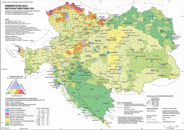
Die Habsburgermonarchie 1848 – 1918. 9 : Soziale Strukturen : Teilbd. 2. Die Gesellschaft der Habsburgermonarchie im Kartenbild : Verwaltungs-, Sozial- und Infrastrukturen ; nach dem Zensus von 1910
Map Full Size Download:
Die Habsburgermonarchie Soziale Strukturen Die Gesellschaft im Kartenbild
Custom and Maker Session Proposal:
None Provided

Dear Erdem,
we sympathize strongly with your approach of visualizing the development of cities in the 19th century. Cities (instead of nations) appear to be useful and fundamental units for investigating the topics of our Tuebingen project. Our approach leads us more to city narratives, e.g. in newspaper correspondences. There seems to be a clandestine convention among the foreign correspondents to convey the efforts of melioration in their respective home cities in the first half of the 19th century. – Maybe rather an observation than an actual discussion item.
Thank you for posting this Erdem, this project will produce some fascinating ways to think about the communities and occupations of communities in the Ottoman cities. It would be great to hear your thoughts on whether the sources (the 19th century Ottoman tax registers and the early 20th century censuses) may conceal even more complexity as residents represent themselves for the use of tax or census records, or those assembling the information.
Thanks Erde, I look forward to meeting tonight. We (historians) can surely profit from understanding more about urban and city space and by visualising data from the past in the ways you suggest can help here. I agree that ‘showing’ this information is profitable as it solves questions and raises new ones. In my own research I have read some very useful and interesting material (but rarely visualised) pertaining to the changing shape of Nairobi (and other colonial cities in Africa) the arrangement of which, like your cities, was strongly structured by ethnicity and race. This spatial structuring also, of course, produced those races and ethnicities and I suppose this is the main question I have which also relates to Konrad’s point: Your project necessarily relies (at first) on accepting the categories of the Ottoman tax registers. Is it possible to visualise the qualitative relationship between fluid urban spaces, occupations, and (for example) ‘Jewish-ness’?
*Erdem, sorry.